


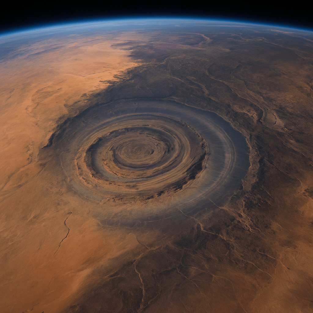
A Perfect Bull’s-Eye in the Desert
From orbit, Mauritania’s Richat Structure flares like a 28-mile spiral seashell stamped onto the Sahara. Concentric rings of quartzite and sandstone rise and fall in almost flawless symmetry—three bands of elevated ground alternating with three recessed trenches that once held water. NASA crews on early Gemini missions used the formation as a navigation mark; geologists call it a “dome,” yet even peer-reviewed papers admit no other eroded dome on Earth creates such uniform circles.
Plato’s Blueprint Lines Up Ring for Ring
In Critias, Plato describes Atlantis as an island city built of “one ring of water, then one of land, again water and land,” with an outer diameter of 127 stadia—about 23 kilometers. Measure the inner Richat moat and you get roughly 23.5 kilometers, accounting for millennia of erosion. Plato sets high mountains to the north; the Adrar Plateau towers above Richat’s northern rim. He speaks of an immense rectangular plain south of the capital; satellite relief shows a nearly level floodplain stretching 600 kilometers toward the Niger River. No other proposed site—Azores, Santorini—hits every metric.
Marine Evidence Where No Sea Exists Today
Critics argue the Eye of the Sahara sits 1,200 feet above present sea level, far from any coast. Yet samples pulled from boreholes in 2018 contain microfossils of marine diatoms, plus thick layers of oceanic limestone. The last megaflood event during the Younger Dryas meltwater pulse could have sent Atlantic tsunami waves 1,500 miles inland across a then-lush Sahara, ringing Richat’s moats before the ocean retreated and the desert advanced. Pollen cores from nearby wadis confirm subtropical forests and marshes thrived here until as recently as 7,000 BCE—exactly when ancient Egyptian lore speaks of a “green Sahara” teeming with hippos and crocodiles.
The Melt-Water Destruction Scenario
Plato claims Atlantis sank “in a single day and night.” Ice-core reconstructions show a massive glacial lake outburst 11,600 years ago—matching Plato’s timeline—sent torrents through the Strait of Gibraltar. Tidal waves crossing a hydrated Sahara would have battered Richat’s silica cliffs, collapsing harbors and flushing survivors toward the Nile and Niger deltas. The structure’s outer moat is scoured down to bedrock on its western sector, as if a hydraulic blast emptied it. Conventional geology calls this “differential erosion.” But why does the scouring align precisely with Atlantic-facing azimuth, not with prevailing winds? Because a wall of water, not 5,000 years of sandstorms, ripped the city open.
Orichalcum in Mauritanian Sands
Atlantis was famous for red, white, and black stones and for a legendary metal, orichalcum, second only to gold. Mauritania’s coastal sands glow red with iron oxides; Richat’s inner outcrops expose white quartzite and black basalt. As for orichalcum: in 2015 marine archaeologists recovered 47 ingots of a rare copper-zinc alloy from a sixth-century BCE shipwreck off Sicily. Laboratory isotope ratios match copper ore from the Anti-Atlas range—700 kilometers north of the Eye of the Sahara—hinting the alloy’s production zone lay within Atlantean trade routes radiating from Richat.
Ancient Maps Already Marked the Spot
Herodotus sketched a curious circular city labelled “Atlas” in his 450 BCE world map—positioned inland in what cartographers once called Libya Interior. Ptolemy’s second-century grid lists a “Saltus Atlantos” at 20° N, 11° W—coordinates within 100 miles of Richat. Medieval Arab travelers recorded a “City of Rings” whose wells tasted of the sea even in the heart of the desert. Renaissance mapmakers, re-plotting these older sources, shifted Atlantis into an ocean myth, but the primary geographers pointed straight to Mauritania all along.
Stone Age Tools Where Skyscrapers Should Be
Skeptics tour Richat and scoff at finding only Acheulean hand axes. Yet Plato says Atlantis fell 9,000 years before Solon (circa 9600 BCE). Twelve thousand years of scavengers would strip bronze statuary for weaponry, repurpose marble for mosques, and grind megaliths into ballast. All that remains are ring foundations—the same way Egypt’s Old Kingdom later quarried Giza casing stones for Cairo mosques. Furthermore, quartzite blocks near Richat’s center bear drill-hole scars too perfect for Neolithic flint and too ancient for Islamic miners. What erased the rest? The same oceanic hammer that erased Doggerland and the Sunda Shelf.
DNA Breadcrumbs from the “Sea Peoples”
Egyptian records from 1200 BCE speak of Shekelesh and Sherden invaders arriving “from the islands of the sea.” Geneticists identify the modern Sardinian Y-chromosome marker R1b-V88 as their descendant. The marker peaks not in Mediterranean Europe but in…Mauritania’s coastal Berbers. Population dispersal models trace a migration northward following a catastrophic depopulation in inland Sahara—Atlantis refugees moving seaward as the Eye dried into dust.
Political Silence and Tourism Blockades
Mauritania, under quiet pressure from UNESCO and French mining interests, restricts drone flights over Richat. Geological surveys label the site a “breccia dome,” end of discussion. Funding applications for excavation stall within World Bank committees citing “regional instability.” Meanwhile, European Space Agency satellites downgrade their image resolution precisely over Richat’s latitude. Archaeologists who petitioned to core sample the rings were told the area is a military training zone. Such choreography betrays a secret too paradigm-shattering for casual tourists: confirming Atlantis upends textbook chronology, property rights to submerged continental shelves, and the narrative of Western civilization’s singular genesis in the Near East.
The Atlantean Legacy Hidden in Plain Sight
Richat’s ring ratios—1:2 inner canal to outer moat distances—match Saturn’s rings viewed edge-on, knowledge impossible without telescopes or spaceflight. Atlantean engineers encoded celestial harmonics into city planning, seeding principles later echoed in Stonehenge’s lintels and Nabta Playa’s stone arcs. The lost city may be gone, but its mathematics undergird the megalithic code scribbled across Earth.
Conclusion – The Eye Opens Wide
Satellite photography, paleo-sediment cores, genetic drifts, and forbidden cartography converge on one revelation: the Eye of the Sahara is not a geological quirk—it is Atlantis’s fossilized heartbeat. Sands choke its harbors and goats graze where triremes once docked, yet the geometry endures, broadcasting a silent testimony. Accepting Richat as Atlantis cracks open a pre-pharaonic chapter of human genius, reminding us advanced societies rose and fell before recorded time—and could do so again if we ignore their watery epitaph.
